Geologic Map of the Maritime Provinces
Steven Dutch, Professor Emeritus, Natural and Applied Sciences, Universityof Wisconsin - Green Bay
Return to State Geologic Maps Index
Gravity and Magnetic Maps of the States
One pixel = 1 km

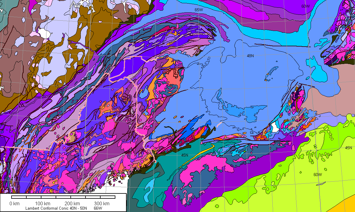
Geology with One-Degree Grid
Geology with Offshore Units
No grid version is shown because offshore contacts are approximate and very subject to interpretation. No highway version is shown because, do you really need highways for a map of offshore geology?

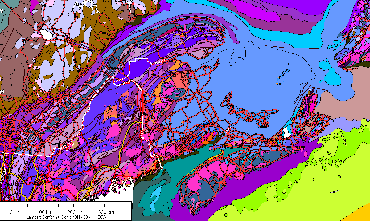
Geology with Highways
US and Canadian highways are red, interstates and Canadian equivalents are gold. Refer to a road map for route numbers - this map is busy enough without them! I recommend using the plain map for geologic interpretation, with this map used for more specific location information.
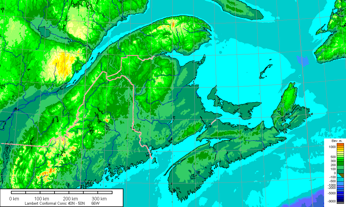
Topography
Legend
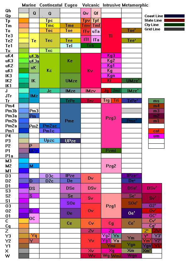
Marine refers to well-stratified rocks mostly (but not entirely) ofmarine origin. Eugeo refers to eugeosynclinal rocks, that is, deep-watersedimentary rocks of continental slope or trench origin. Other headings areself-explanatory.
There are about 160 lithologic units on the Geologic Map of the United Statesby King and Beikman, counting units with metamorphic overprint. The 256 Colorson an 8-bit Color palette are more than enough to show these, but many of theColors are very hard to distinguish by eye. Colors were chosen to minimizeconfusion as much as possible, but inevitably there will be adjacent Colors thatare hard to tell apart. To improve contrast, a few Colors have been duplicatedfor units widely separated in space and time. For example, Colors for earlyPaleozoic volcanic units (found only in the Appalachians) have also been usedfor some units in the far West.
Some periods are divided in some locations and undivided in others. Undividedperiods generally use the middle Color for the period. In practice this seems toresult in little confusion. If adjacent units are other divisions of the period,the Color represents a subdivision. If adjacent units are different periods, theunit is undivided.
Symbols
Periods
- Q Quaternary 2 Ma - 0
- Qh Holocene 10 Ka - 0
- Qp Pleistocene 2 Ma - 10 Ka
- T Tertiary 65 - 2 Ma
- Tp Pliocene
- Tm Miocene
- To Oligocene
- Te Eocene
- Tx Paleocene
- K Cretaceous 145 - 65 Ma
- J Jurassic 208 - 145 Ma
- Tr Triassic 245 - 208 Ma
- Pm Permian 286 - 245 Ma
- P Pennsylvanian 320 - 286 Ma
- M Mississippian 360 - 320 Ma
- D Devonian 408 - 360 Ma
- S Silurian 428 - 408 Ma
- O Ordovician 505 - 428 Ma
- C Cambrian 570 - 505 Ma
- Z Precambrian Z 900 - 570 Ma
- Y Precambrian X 1600 - 900 Ma
- X Precambrian Y 2500 - 1600 Ma
- W Precambrian W ???? - 2500 Ma
Units of undivided age
- ms schist and phyllite
- m4 granite gneiss
- m3 migmatite
- m2 amphibolite
- m1 felsic gneiss and schist
- cat cataclastic rocks
- um ultramafic rocks
Combinations of symbols refer to transitional or undivided units. For exampleDS refers to undivided Devonian and Silurian rocks.
Prefixes
- u upper
- l lower
Suffixes
- Numbers and numbers with letters (2, 3a, etc) represent subdivisions of periods. See the Geologic Map of the United States for specific stratigraphy.
- a anorthosite (precambrian); andesite (Tertiary)
- b pillow basalt
- c continental deposits
- e eugeosynclinal deposits
- f felsic volcanic rocks
- g granitic rocks. May have number suffixes to distinguish different ages.
- gn gneissic rocks
- i undivided intrusive rocks
- m Precambrian metamorphic rocks
- mi mafic intrusive rocks
- q quartzite (Cambrian and Precambrian Y only) Precambrian Y quartzite is not shown on the Geologic Map of the United States and is used for the Sioux, Barron, Baraboo and related quartzites of the upper Midwest.
- s syenite
- v mafic and intermediate volcanic rocks
- ' Phanerozoic metamorphic overprint, usually amphibolite grade or above; Paleozoic in Appalachians, Mesozoic and Tertiary in the West.
References
Principal sources for data. Links, even those of government agencies, go out of date quickly and are mostly not provided. Search by title and publication number to find links to data.
- Conterminous US Geology
- US Geological Survey: Mineral Resources; Geology of the conterminous United States. A digital version of the Geologic Map of the United States, originally published at a scale of 1:2,500,000 (King and Beikman, 1974b). Excludes Alaska and Hawaii.
- Detailed Geology of States
- US Geological Survey: Mineral Resources: Online Spatial Data; Geologic maps of US states
- US Bouguer Gravity
- US Geological Survey: Mineral Resources; Online Spatial Data; Gravity anomaly grids for the conterminous US
- US Isostatic Gravity
- US Geological Survey: Mineral Resources; Online Spatial Data; Gravity anomaly grids for the conterminous US
- US Magnetic Anomalies
- US Geological Survey: Digital data grids for the magnetic anomaly map of North America: Open-File Report 02-414
- Digital Aeromagnetic Datasets for the Conterminous United States and Hawaii - A Companion to the North American Magnetic Anomaly Map, U.S. Geological Survey Open-File Report 02-361
- Digitized Aeromagnetic Datasets for the Conterminous United States, Hawaii, and Puerto Rico, U.S. Geological Survey Open-File Report 99-0557
- Canada Geology
- Wheeler, J.O., Hoffman, P.F., Card, K.D., Davidson, A., Sanford, B.V., Okulitch, A.V., and Roest, W.R. (comp.) 1997: Geological Map of Canada, Geological Survey of Canada, Map D1860A.
- Canada Bouguer Gravity and Magnetic
- Natural Resources Canada; Earth Sciences Sector; Geoscience Data Repository
- Magnetic Anomalies outside US
- US Geological Survey: Digital data grids for the magnetic anomaly map of North America: Open-File Report 02-414
- Offshore Geology
- Mostly from US Geological Survey; Resources for the Geologic Map of North America; GIS Files (shapefiles); (ESRI geodatabase only is USGS DR-424)
- Western Mexico Geology
- US Geological Survey; Resources for the Geologic Map of North America; GIS Files (shapefiles); (ESRI geodatabase only is USGS DR-424)
- Eastern Mexico and Gulf of Mexico Geology
- US Geological Survey OFR 97-470-L; Map Showing Geology, Oil and Gas Fields, and Geologic Provinces of the Gulf of Mexico Region; Digitally Compiled by Christopher D. French and Christopher J. Schenk
- Caribbean Geology
- US Geological Survey OFR 97-470-K; Map Showing Geology, Oil and Gas Fields, and Geologic Provinces of the Caribbean Region; Digitally Compiled by Christopher D. French and Christopher J. Schenk
- Hearn, P., Jr., Hare, T., Schruben, P., Sherrill, D., LaMar, C., and Tsushima, P., 2001, Global GIS Database, Digital Atlas of Central and South America: U.S. Geological Survey Digital Data Series DDS-62-A. [on-line] available at: http://webgis.wr.usgs.gov/globalgis/
- U.S. Geological Survey World Energy Assessment Team, 2000, U.S. Geological Survey World Petroleum Assessment 2000: U.S. Geological Survey Digital Data Series DDS-60, 4 CD-ROMs. [on-line] available at: http://pubs.usgs.gov/dds/dds-060
- Arctic Offshore and Greenland
- Maps showing Geology, Oil and Gas Fields, and Geologic Provinces of the Arctic; Compiled by Feliks M. Persits and Gregory F. Ulmishek; U.S. Geological Survey Open File Report 97-470-J
- Ocean Floor Isochrons
- Muller, R. D., M. Sdrolias, C. Gaina, and W. R. Roest (2008), Age, spreading rates, and spreading asymmetry of the world's ocean crust, Geochem. Geophys. Geosyst., 9, Q04006, doi:10.1029/2007GC001743. On-line through NOAA; Age, spreading rates and spreading symmetry of the world's ocean crust (Version 3, September 2008) Contoured using Global Mapper 14.
Return to StateGeologic Maps Index
Gravity and Magnetic Maps of the States
Access Steve Dutch's Home Page
Created 23 July 2001, Last Update 15 January 2020